This page was updated March 2024.
Golf

- Nehoiden Golf Course (private, 9 holes)
- Wellesley Country Club (private, 18 holes)
Golf course beyond Wellesley
- Leo J. Martin Memorial Golf Course (Weston)
Skating
The town does not sanction skating on any public ponds, lakes, rivers, according to the fire department and recreation department. See our Kid Stuff page for info on indoor skating.

Sledding
Elm Bank Reservation off Rte. 16 at the Wellesley/Natick border. Fast, but not too fast hill that offers something for older and younger kids. Most sledders seem to aim for the big tree on the right side of the hill, younger kids tend to stay to the left, which is less steep. To get there, simply follow the road to the right once you cross over the bridge and you’ll see the sledding hill to your left. Parking is at the top of the hill.
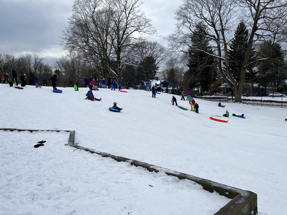
Kelly Memorial Field on Elmwood Rd., adjacent to the Bates Elementary School. The sledding hill is to the left of the ballfields as you enter from the school parking lot. It’s a long, not-too-steep slope, with a smaller hill for little kids on the side.
Nehoiden Golf Course: Not sure the course owners really want you to sled or ski there, but they don’t seem to fight it. Sledding is popular on a hill across from the Rte. 16 entrance to Wellesley College. A plastic fence has been erected to catch those who might otherwise coast into the road.
Schofield Elementary School: A moderate hill that tapers into the ballfields. Houses at the top of the hill. Can get chilly on a windy day, as the fields are wide open. Park at Schofield at 27 Cedar St.
Severance Hill at Wellesley College. The hilltop is at Severance Hall and behind the Davis Museum and Cultural Center. (Note: the Davis Museum is closed through February 2024.) Students are known to zip down on cafeteria trays. This hill is not for those with common sense.
Wellesley Country Club. We hear hole 11 is a good one.
Wellesley Recreation Department/Warren Park has a moderate hill, good for young ones. There’s also a playground. Located on Rte. 16/Washington St.
Plans are in the works for a $2M Warren Park playground renovation, which will likely begin in fall 2025. This stemmed from a Department of Public Works review of playground status in terms of equipment age and style, accessibility, and usage (the town maintains 18 playgrounds on 16 properties). More here.
Cross country skiing
Weston Ski Track: Ok, it’s not technically in Wellesley, but close enough. Cross country ski and snowshoe rentals, lessons.
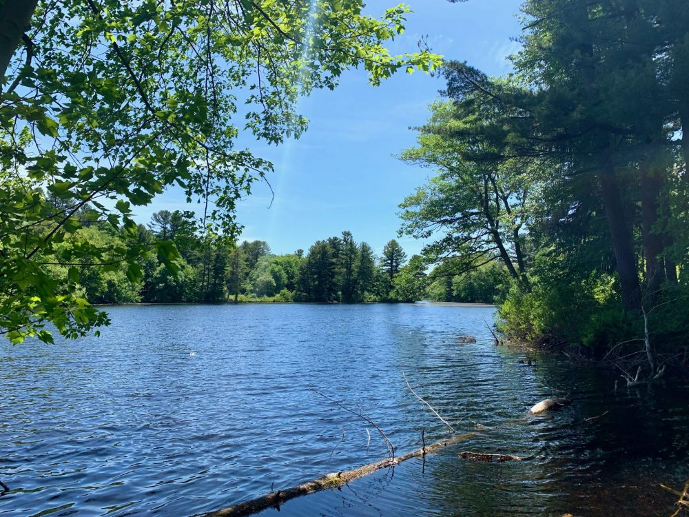
Wellesley trails and Wellesley Country Club (seen here) are among the best spots in town.

Basketball hoops (outdoors)

- 7-foot-high basket in front of Bates Elementary School at 116 Elmwood Rd.
- Fiske Elementary School has short hoop in front and a couple of regulation hoops in back (map).
- Hardy Elementary School—hoops not available while school is under construction (updated Aug. 2023)
- Hunnewell Elementary School—hoops not available while school is under construction (updated Aug. 2023)
- Ouellet playground (map) has a nice court with 2 regulation-height hoops.
- Perrin Park (map) has 2 regulation hoops and 2 7-footers criss-crossing on one court.
- Phillips Park (map) has 2 regulation hoops on a court.
- Schofield Elementary School has 3 hoops, 2 regulation and one about 8-feet high (map).
- Sprague Elementary School has 2 regulation height hoops next to the playground (map).
- Upham Elementary School has 5 hoops (4 regulation and 1 about 6-feet high). Map.
Running/walking
Measure the distance you run/walk: http://www.gmap-pedometer.com/ Wellesley running/biking maps
Outdoor tracks
Wellesley High School
50 Rice St., Wellesley, MA

Wellesley College track

More running
Boston Marathon course: Wellesley stretch of the Boston Marathon course goes along routes 135 and 16, in between miles 11/12 and just before the mile 16 marker. These markers are painted onto the double yellow lines on the road (though tend to fade through winter). We’re talking about the Pond Rd/Rte 16 intersection to the Wellesley/Newton border, shortly before Rte. 95.
Running every street in Wellesley: One man’s diary of this odd accomplishment (see bottom of this page)
Tennis and pickleball (outdoor courts)

Hunnewell Field has 8 courts, plus a practice wall, with lights at night from May-August for those who buy tags via the town’s recreation department. Map to courts. 3 courts at Schofield Elementary School playground (27 Cedar St.,Map ). 4 courts behind the Middle School (down the hill). Map.
Pickleball has taken the country by storm, and Wellesley is no exception. As of July 2023, the town has been figuring out ways to provide noise relief to neighbors of pickleball courts at Sprague Field and Perrin Park, and fair court access to pickleball and tennis players (tennis still accounts for two-thirds of court reservations). Most updated information, as well as court reservations, here.
Trails (hiking, running, cross country)
Here’s a link to the town’s Trails Committee. The site includes descriptions of public trails, some of which can be skiied as well as hiked or run.
The Wellesley Conservation Land Trust is a private land trust; all its properties are open to the public. The Land Trust’s mission includes protecting and preserving Wellesley’s natural environment and maintaining its sanctuaries through the contributions and participation of residents. The WCLT provides free programs every spring and fall.
Water sports
Canoeing/Kayaking
The Charles River twists through Wellesley in a few spots. One good launch site is at Elm Bank Reservation about 3/4 of the way around the paved road.

Participate in the Run of the Charles Canoe and Kayak Race in April (races from 6 to 26 miles, open to all skill levels). Charles River Canoe and Kayak in Newton and Natick provides lessons, rentals, guided tours.
Learn more about the river at the Charles River Watershed Association.
Fishing
Fishing licenses can be ordered online here.

Swimming

Swim at Morses Pond. Find info here on beach tags, swim lessons. Friends of Morses Pond Association works to protect and preserve the pond.
Before there was The Swellesley Report, there was my running of every street in Wellesley. Hope you might find this useful. BB
Tuesday, July 20, 2004
It’s over….have finished running all Wellesley streets. The final 5: Church, Waban, Wiswall, Louis and Weston Terrace This wasnt the most efficient of runs…4 of the streets are clumped together at the end of Weston Rd, Louis at the opposite end, almost in Weston. Church, Waban etc are bunched together in downtown Wellesley. Wiswall is tiny dirt road, Weston is a short steep hill leading to townhouses that appear to be Wellesley College territory. Louis is a nice street, a mix of old and new homes, with one homeowner’s automated sprinkler system madly showering the too green lawn on this rainy morning. I’ll follow up with a recap of some favorite streets, etc. My next goal? Navigate all 80 miles of the Charles? I dunno…
Friday, July 16, 2004
Wellesley streets: Mica, Willow, Willow Park, Mulbern, McLean, Fife, Dunedin, Ashmont, Webb, Echo, Dearborn, Hayden, Sheehan, Cedar Ter, Burke and introducing….Burnett A collection of largely dead-end dirt roads and offshoots of Rte. 9 made up my last big run in doing all the Wellesley streets. Just one more run downtown to nail the last 5 streets. Dunedin is perhaps the steepest hill in town. I thought I was headed over a precipice when I first started heading down it. McLean is an odd street, half older small homes and half bigger new homes. Also, a new street with big new houses is Burnett, which is off of McLean. Got confused when I got to Dearborn, which according to my map has several streets off of it, including May and Park and Reservoir. No sign of them though, just the big Gateway office park. Guess they got nixed during that development? I ran around the parking lot a bit, figuring that covered my bases. I started the run at Mica off 16. Mica is basically an alley between a couple of stores and across from Paparazzi. I ran up River St, which tracks the Charles at Finlay dam, a nice enough place to sit on a bench and check out the river action. A boulder with a plaque there says George Washington entered town around there back in the 1700s….
Monday, July 12, 2004
Wellesley Streets: Wellesley Hills area….Bow, Prospect, Crescent, Fairbanks, Glen, Riverdale, Montvale, Intervale, Boulevard, Ledyard, Columbia, Crestwood, Dennis, Edgewater, River Glen, Kirkland Cri. Shaw, Clifton, Southwick, Sylvester, Pine Ridge, Greenlawn Bow and Fairbanks deliver some good up and down action in a nice hood over behind the new rec center. Some of these streets, such as Boulevard, brush right up against the Charles and Newton. In fact, there’s an MDC sign on Boulevard that alerts readers they can only head into the woods on pleasure vehicles. Was hoping this would be a trail, but it really is just a short path to the river. Plenty of no parking signs in this general area….I guess they dont want people walking over to the T. Glen slopes up as it heads from Rte 16 into Weston, while Riverdale and River Glen slop down from Glen for some good hilly running. The houses in this neighborhood are a mix, though in general an older-looking locale with a few mansions and wannabee mansions sprinkled in.
Spotted one of the older houses I’ve seen in the area on Columbia (1740 it says on the plaque).
Sunday, July 11, 2004
Wellesley streets….nearing the end. Cedar, Bird Hill, Saunders, Washburn, Heckle, Bancroft, Barton, River Ridge, Minuteman, Harris, Duxbury, Lantern, William, Oriole, Redwing, Bluebird, Bobolink, Hunting, Maple, Bethel, Charles, Walnut, Walnut Pl, Charles River path This wasnt the most scenic tour of Wellesley, though some nice parts, including the Charles River trail, which I took from the David Ouillet memorial baseball field/basketball court off of Cedar right over to the rec center on 16 and Walnut, where I started my run. The Charles River trail, which featuers yellow arrows, does indeed go alongside the mighty Charles, including a couple of bridges. Hit a few short hills off 16, including Bird Hill and Heckle, which feeds into Bancroft, which runs into a Rte 9 service road. Streets such as Minuteman, where the Wellesley location for the National Guard is based, are roads I cant imagine would be on too many a route, as they shoot off Rte 9 near where Rte 95 intersects. Barton is home to what must be Wellesley’s biggest public housing area. I’m 2 runs away from finishing things up. A medium-sized section also off Cedar and then a few streets here and there, mostly near Weston Ave. Should wrap it this week…..
Friday, July 09, 2004
More Wellesley Streets and St. Mary’s Cemetary: Cedar, Lincoln, Lincoln Cir, Hunnewell, Wellesley, Jefferson, Madison, Monroe, Jackson, Hastings, Sheridan, Comeau, Brookside. Brookside is one of my favorite roads to run. It intersects with Oakland, which passes by Mass Bay Community College and Longfellow pond and assorted trails that lead to the Fiske School, among other places. Brookside is yet another “private way” in that it goes along the Wellesley Country Club golf course. It’s a twisty sorta hilly road, and you need to watch yourselves as cars zip along and cant always see you around bends. Hunnewell is also a nice incline or decline depending on which way you are heading. It, along with Cedar, surround St. Mary’s Cemetary, which has a couple of the more impressive monuments you’ll see in a local cemetary, including statues of a suffering Jesus on big boulders just inside the Hunnewell St. entrance. The presidential streets off of Hunnewell, such as Jackson and Jefferson, offer up plenty of American flags, as you might expect, especially since I was running this route on July 4 weekend. Kinda got lost on this run, as I wound up straying into Needham and Central St before figuring things out.
Monday, June 28, 2004
Wellesley streets, mainly off Glen: Glen, Carisbrooke, Chiltern, Ox Bow, Highgate, Hillside, Orchard, Glen Cross, The Waterway, Ravine, Old Farm, Valley, Old Town, Springdale, Sylvan, Glenbrook, Boulder, Boulder Ext. Washington Ct, Indian Springs, Dean, Ridgeway, Carisbrooke Reservation, segment of Crosstown Trail Carisbrooke might be the schmantziest street in the town, even featuring a towering pink house and one yard with a mystical cone sculpture. Good long steady climb up this road. Carisbrooke Reservation, which is off Glenbrook near Weston is a half mile wooded trail. Nothing too spectacular, but worth a look if running in the area. Nicer is the Crosstown trail segment between Fuller/Woodlawn and Rte 16 across from the new Rec center. This is also about half a mile but on flat trail, passing by a stone hut with a nice piece of graffiti (“Thomas”). Highgate residents live the high life, one with a tennis court, another with putting greens and a hoop court, all with lavish landscaping. Some dirt roads in this area, such as Sylvan and Boulder Ext, which is also a “private way.” Overall, a nice area to run, including Springdale and others that go along Cold Stream.
Tuesday, June 22, 2004
Wellesley streets: Commonwealth, Bay State and Pine I knocked off just 3 streets today while on a longer run on Wellesley’s Rte 16 marathon stretch. Pine immediately gave me some shade relief coming off of 16. Commonwealth is a teensy little “private road” off Bay State, a nice street.
Friday, June 18, 2004
Wellesley streets: Colburn, Chestnut, Rock Ridge, Roberts, Oakridge, Essex, Sprague Had a little cleaning up to do today on streets I hadnt hit while in these neighborhoods near Cliff Rd and Rte 9. Chestbut turns into Rock Ridge and becomes quite the steep hill at that point. Colburn featured a note from one neighbor politely asking others not to dump grass clippings on his property. Noticed a house for sale on nearly every street I hit today. I took Lowell over toward Roberts and Sprague, both of which intersect Rte. 9.
Tuesday, June 15, 2004
Morses Pond area, Natick side: Shore Dr, Upson, Lexington, Pickerel, Pickerel Ter, Pine Ridge, Ottaway, Stuart?, Dale, Edgemoor, Hilcroft, Stevens, Frost Cir, I parked at Sargent Field on Oak St and headed toward Morses Pond along Pickerel (hilly, dirt) and Shore Rd, which have great views of the pond, though the neighbors dont any of you looking at them. Lots of private this and private that signs, plus no parking here to there. Big houses going up among shacks in this crowded but apparently choice spot. Crossing over Rte 9 I hit Edgemoor, a nice up and down road that parallels Overbrook and is connected by a couple of small grassy parks. The water was gushing near Cedar Brook over a little dam at Reeds Pond. I’m not quite sure I hit Stuart Sts, which on my map is a small one off Rte 9, but signage wasnt there as far as I could see. I ran in and out of some short alleys near the Wellesley Inn and Lee Volvo, figuring one of them must have been it.
Wednesday, June 09, 2004
Hunnewell playground/fields area: Rice, State, Atwood, Aberdeen, Morton, Sessions, Smith, Twitchell, Cottonwood, Seaver, Peck, Park, Framar, Hopkinson, Dexter, Wilson, Clifford Many of these streets, such as Morton and Twitchell, criss-cross the brook path, a fine running trail that parallels the Boston Marathon course. Rice, State and Seaver circle around the high school. Seaver includes several dirt paths through the woods and to the school. Impressive on Seaver is number 40, which I gather is some sort of schmantzy condo building looking high above the street. Some good short hills, including Peck and Hopkinson, which is twisty one.
Monday, June 07, 2004
Wellesley Streets: Cranmore, Bellevue, Appian Monadnock, Wachusett, Falmouth, Falmouth Cir, Yarmouth, Yarmouth Ext, Salem, Bucknell, Sturbridge, Sudbury, Dukes, Mountview, Deerfield, Hampshire, Nantucket, Shelburne Ran the streets with mountain and Cape names today, even left the ramshackle neighborhoods of Wellesley for those of Weston. As their names hint at, Cranmore, Bellevue etc are hilly…nice up and down running on these streets. Mountview actually does provide a nice vista. Deerfield is short and steep. Check out Falmouth Cir for a fun treehouse and Falmouth feeds into Scotch Pine, where you run past a private pollen-peppered pond. Lots of stone walls among these streets. Went back to my car by way of the shiny Bates school. They’ve got the bounciest surface surrounding their climbing structures…a shiny new school too.
Thursday, June 03, 2004
Sabrina Lake/Locust lane Hey, not everything is about Swellesley. I went slightly afield today to run up Locust Lane, off Dover Rd., which appears to be technically in Needham. Assorted signs dot Dover Rd. telling you the cops are watching this public water supply area etc. Though I trotted down Locust Lane, through increasingly thick, no doubt tick-infested grass, to come upon Sabrina Lake. There’s an opening to the lake with a rope hanging from a tree. So it appears someone aside from me has been checking out the area. I looped around on this pine needle-covered path to come back out on Dover Rd. I have a feeling there’s more to explore here, so will need to investigate further down the road…..
Wednesday, June 02, 2004
Upham school area: Hampshire, Tanglewood, Lowell, Wynnewood, Trinity, Fox Hill, Chatham Cir, Taylor, Audubon, Bristol, Mountview, Albion, Barnstable, Plymouth, Arnold, Old Colony Another great running spot, lots of hills, criss-crossing streets, low traffic and a variety of sights. Chatham Cir loops near Abbott Pond on Rte 9, I didnt see any obvious entry point to the pond, which looked pretty swampy. Nice hills on Hampshire, Albion. Bristol, Wynnwood, Tanglewood all head uphill toward Upham school, where the basketball courts are also on a hill. That’s gotta be a pain.
Cliff Rd and beyond: Cushing, Dinsmore, Lowell, Albion, Greenwood, Bradford, Edmunds, Woodcliff,Cypress, Rockland, Kimlo, Gilson, Hawthorne, Sawyer I literally crossed onto the other side of the tracks today, running among the mostly stately homes on Cliff Rd and west of it. Even the baseball pitchbacks are nicer in this part of town. Kimlo is another of those “private ways” and these homes really do have some nice privacy on this lush winding road. Dinsmore is a dirt road that I imagine the locals like to keep that way to give it a private feel. Some good hills in this area, such as Sawyer.
Monday, May 24, 2004
More Wellesley streets: Durant, Garrison, Thomas, Claflin, Hamilton, Bowdoin, Rutgers, Mansfield, Westminster, Norwich, Bryn Mawr Timed this run just wrong. Poured the second I started, stopped the second I finished. Ran streets on both sides of Weston Rd, including Thomas and Bryn Mawr, which feed into Perrins Park, a nice little park and ball field area. Then went over to some streets in between Weston and Rte 9, including the short but steep Rutgers and sloping Mansfield, which includes plenty of nice homes with big yards. Westminster is off on its own off of route 9. Also ran Westgate, which I’ve run before. A nice wide street that connects lots of other streets near Boulder Brook and the Bates elementary school.
Friday, May 21, 2004
Dana Hall/Woodlawn Cemetery area: Brook, Fuller Brook, Middlesex, Vincent, Farm, Wildon, Eisenhower, Juniper, Hobart, Swarthmore, Radcliffe, Southgate, Marvin, Hampden, Dana Some of these roads arent very well marked or I cant see very well (Dana, Vincent, Farm) on the Dana Hall campus. Woodlawn Cemetery is one place I’d never been. Nice place to run, some steep hills and plenty of space left to bury you if you croak on the spot. Swarthmore is a road you’d never run if you weren’t looking for it given that it veers off of busy 135/Wellesley Ave. There’s an aqueduct off of Fuller Brook, signs warn not to trespass, not sure how real that warning is. I didnt test the terrain today.
Monday, May 17, 2004
Wellesley Farms area: Woodlawn, Woodlawn Oval, Squirrel, Elm, Fuller, Croton, Chapel I ran this through area while in the middle of a longer run. Hadnt been in this spot before, some very nice streets with big but not horrible houses and spacious yards. Big campground like house with a tennis court on Croton, which leads up past the Wellesley Farms T stop on the commuter rail and a small body of water I believe called Wight Pond. Croton, Woodlawn and Elm all intersect with Rte 16. No sign of farms in this part of Wellesley Farms though.
Friday, May 14, 2004
Wellesley streets: Linden, Highland, High Top, Westerly, Hollis, RR Ave, RR St, Upwey, Calvin, Geraldine, Ayer, Alba, School, Bernard, Wall, Oak, Pleasant, Everett, Donazette, Stearns, Francis, Delanson, Windemere Rd, Windemere Ln I pinballed back and forth tween Linden and Rte 9, hitting a bunch of streets in between. Being a hill guy, my favorites were Hill Top and Highland, which lead to a little ropes course that passersby are warned not to fiddle with or Johnny Law will come down on you. The course is near the Sprague Rec center. Also nearby is the middle school, which is off Calvin, Kingsbury etc. Windemere was about the nicest of the streets, finely manicured yards. Many of these other neighborhoods are modest, with a good mix of townhouses thrown in. A thin waterway called Cold Spring cuts through Linden in this area and the commuter rail into Boston runs alongside Linden, which is home to a number of stories, including a couple of bakeries.
Wednesday, May 12, 2004
Boulder Brook Reservation and nearby streets: Richland, Northgate, Wingate, Auburn, Oxford, Meadowbrook, Cavanaugh, Chesterton, Boulder Brook, Pine Plain, Beverly I parked at the Elmwood St lot .3 mi from Weston Rd. for the Boulder Brook trail, which as I followed the purple arrows along the trail appears to be a mile or so from one end to the other. There are in fact some big boulders along the way. You also cut through a meadow and behind the Bates School baseball field. Bit of an incline toward the end of the marked trail. The trail also seems to jut out in various directions which I did not explore. A number of the streets on my run (Meadowbrook, Chesterton, Richland etc spilled into the trail via assorted wooden bridges. Nice neighborhood, flat.
Tuesday, May 11, 2004
More Wellesley streets: Kenilworth, Kenilworth Cir, Pembroke, Cornell, Colgate, Lehigh A nice neighborhood where the sizeable houses have pretty big yards. This hood dribbles into Needham.
Tuesday, May 04, 2004
More Wellesley streets, Overbrook area: Shirley, Beechwood, Beechwood ter, Nobscot, Leewood, Parker, Cedar Brook, Overbrook, High Ledge, Sunnyside, Marigold, Oakdale, Manor, Evergreen, Argyle, Fenmere, Brookdale, Woodfield, Mayo, Berkeley, Colby, Princeton, Dell, Meadow I parked on Elmwood at the Boulder Brook trail lot just past the baptist church, then did a look from Weston, up Shirley, onto Overbrook and back to Weston via Manor. Lots of cozy neighborhoods on the loop streets that mark Shirley. Lots of stubby streets off of Manor, which runs from the town of Weston to Weston Rd. in Wellesley. My favorite are was running from Cedar Brook to Overbrook, which comprise rolling hills and run over a brook, I believe called Bogle Brook. The water was running hard this day, following the rainiest of all Aprils. Also, Overbrook oversees Reeds Pond. Mayo is a surprisingly long (half mile?) street off of Weston.
Sunday, May 02, 2004
More Wellesley streets…Mass Bay Community College area: Oakland, Oakland cir, Eaton, Seaward, Bemis, Maugus, Maugus Hill, Clocktower, Wareland, Cunningham, Grantland, Putney, Partridge, Priscilla, Priscilla cir, Standish, Standish cir, Dudley, Carver, Brewster, Winslow, Oakland St isnt ideal for running because it crosses Rte 9 but a lot of these streets are good for running. Putney is a good hill, as are Wareland, Maugus Hill and Clocktower (the last three are sort of off of Rte 16, near Whole Foods store). Some nice houses in this area, though maybe a few less mansions than usual given the proximity of Rte 9. Clocktower is full of big houses and they have nice views of forests all around. A couple of the streets, such as Priscilla and Carver, feed into paths that go around Longfellow pond. Oakland St. highlights include Mass Bay Community College and the Sisters of Charity retirement home.
Friday, April 30, 2004
Forrest, Abbott, Laurel, Laurel Terr, Clark, Berkshire, Windsor,Inverness,Lincoln,Paine, Grant,Rice, Franklin, Arlington, Livermore,Clovelly, Caroline, Prescott, Fletcher, Spruce Park Beautiful a.m., first time this year I get to wear shorts/tshirt at 6 a.m. Ran up Forrest, down Abbott and the streets in between. These streets are packed in between the high school and Centennial Park. The Brook Trail runs through here as does the Caroline Brook. Abbott and Forrest are avenues with stately mansions aplenty. The loop off Abbott to Windsor/Lincoln/Inverness is nice, going up a hill on Lincoln, then down, then up Windsor. This are abuts the Wellesley Country Club. Rice and Paine head toward the high school. Abbott and Forrest spill out onto Rte. 16. Even a couple of dirt roads on this tour, including “private way” Caroline St.
Friday, April 23, 2004
Overbrook area of Wellesley off of Weston Rd: Fells, Fells Cir, Lafayette, Regis, Russell, Bay, Bay View, Beach, Shadow, Stonecleve, Lake, Kendall, Fisher, Morrill, Amherst Water was the theme today, running in pouring rain and nearby Morses pond. Lake, Stonecleve, Beach, Bay, Bayview etc are all squished in around the pond….like so many areas of Wellesley the section is labeled as a private way. A mix of small, beaten down, moss-roof houses and shiny new ones with waterfront or semi-waterfront views. Not much in the way of hills in here. Kendall leads into a trail system that goes around the pond. Shadow is in the shadow of Rte 9 and is a bit on the noisy side.
Sunday, April 18, 2004
More Wellesley streets: Pilgrim, Pilgrim Cir, Cleveland, Hardy, Willow, Lawrence, Mellon, Hickory, Woodbine, Pinewood, Pinewood Cir, Larch, Service, Alhambra, Ingersoll, Woodland, Elmwood, Linwood, Wedgewood, Earle, Martin, Wilde, Brookfield, Brookfield Cir, Haven, Massasoit Nice neighborhoods off of Weston around Rte 9. Rte 9 noise is pretty darn loud over on Pinewood and nearby streets. A number of these streets feed into Rte 9, including Martin. Not too much in the way of hills, a bit on Cleveland/Haven.
Friday, April 16, 2004
Eliot, Carlton, Cameron, Woodside, Woodway, Woodridge, Temple, Sterling, Dewing Path, Lathrop, Amherst Rd, Spring I took it on the road over near Dana Hall school today and got myself some good hills to run, especially Temple, Woodside and Sterling. I came out on Benvenue at one point and ran past an orange house from 1740.
Thursday, April 08, 2004
Longmeadow, Sabrina roads Had missed these connected streets last time I ran in the area. Great looking neighborhood, which essentially has its own park in the middle of the looped streets. Across the street is Beard Way and the entrance to the proposed/partly finished Sudbury Path, which leads to the Ridge Hill Reservation in Needham, another nice place to run or walk. Its entrance is on Charles River St. The reservation in includes a 30-plus station fitness trail and numerous walking trails.
Monday, April 05, 2004
Abbott St., Upland, Church, Kingsbury, Worcester, Cliff, Monadnock, Greylock, Scotch Pine Cir, Scotch Pine, White Oak, Woodchester, Oak Cliff, Ledgeways, Hundreds Rd, Hundreds Cir., Lanark, Surrey, Suffolk, Garden Pl, Garden Rd, Edge Hill.,Peirce, Royalston, Stanford, Westgate I’m probably lucky someone in the Cliff Rd. area didnt call Johnny Law on me this a.m. as I ran around, pocket tape recorder in hand, talking to myself as I ran the streets in this area of Wellesley and along the Weston border. Plenty of impressive tudor, brick, etc. homes and yards in this area, along Cliff and on the “mountain” roads of Monadnock, etc. Monadnock is a fun winding road with ups and downs, leading to Weston and the Northeastern University Henderson House, which is for corporate meetings, etc.
Friday, April 02, 2004
Weston, Linden, Howe, Crest, Curve, Avon, Sunset, Harvard, Summit, Granite, Crown Ridge, Maurice, Ivy, Ivy Cir, Poplar, High Meadow, Oakencroft, Strathmore, Dorset,Lilac Braved the drizzly cold and ran a bunch off streets just off downtown Wellesley, starting on Weston. Curve is in fact curvy. Crest does have a crest. The houses are huddled near each other in this neighborhood. Overall, some decent running in here, with some hilly parts, such as Popular going down to Weston. Dorset is a dirt road with a private way sign on it, but then again, a lot of these streets have private way signs on them. I dont think so. You can hear Rte. 9 traffic pretty well back here, near dead end Lilac. Interesting looking stone block house at top of Crown Ridge.
Wednesday, March 31, 2004
Beard Way and Sabrina Farm Rd. Knocked off two more Wellesley streets, or at least I think so. Beard isnt on my map, but appears to be Wellesley, off Grove near Sabrina Lake. Beard looks to be a nice old neighborhood being ripped up to build a bunch of huge new houses. End of Sabrina includes a glimpse at a pond, I believe, and no tresspassing signs. Couldnt tell if there was actually a farm there….
Friday, March 26, 2004
Dead end day: Benvenue, Cartright, Vane, Tappan, Winthrop, Benton, Ingraham, Arden, Greenbough My quest to run every street in Wellesley continued today. Turns out I ran up a lot of dead ends today. At least they are dead ends for cars, but feed into the Fuller Brook path for runners. Ingraham is off Dover Rd. and Vane, Tappan, Winthrop and Benton are all dead-end roads off of Ingraham, which is a semi-steep hill that curves into Grove and starts across from the Nehoiden Golf Course at Wellesley College. I only ran part of Benvenue today. It passes by the Ten Acre Country Day School, which I know has a nice summer camp. I stumbled across a cut-through path between Benvenue and Cartright that’s labeled Beebe’s Meadow (there’s a small meadow on one side). There’s a Wellesley Trails sign here that mentions a proposed path called the Sudbury Path that would go through this area. Cartright’s a nice street to run, it weaves into Needham. Along the way you see a huge greenhouse at one yard and a big garden at another.
Poet’s corner: Longfellow, Shelley, Fairbanks, Tennyson, Thackeray, Whittier,Emerson, Hunting Cir., Kipling, Damien, Walnut and River Poet’s corner is a neighborhood I’ve run by a zillion times on marathon training runs and the marathon itself, as Longfellow intersects with 16 along the Boston Marathon Rte. near the Wellesley Rec center, which is being revamped. Longfellow is a longish hill that hits Rte.9 on the downslope. Emerson is also a good hill, running parallel to Longfellow. Houses in this hood are built close to one another. The buildings are a mishmash, some from the 1880s, others brand new, some brick and castle-like, others McMansionlike. Fairbanks is a fun twisty road that cuts across Walnut. The most colorful site in this area is a small white house on Hunting Cir. that has solar panels on the roof and features brightly colored window and door frames (purple, green, red, yellow, orange and blue if i recall correctly). I also ran on Walnut, which took me over to River, about the last street in Wellesley before you hit Newton. River, as the name suggests, abuts the river, the Charles in this case. It runs by a housing project and believe it or not, a “rapids” portion of the Charles. You can cross the river via the Mary Hunnewell Fyffe Footbridge at the Cordingly Dam, which includes a fish run area. I caught up with some friends running the Boston Marathon while on this run and one told me the Dam is especially attractive in deep winter when it is partially frozen over but still spitting out water this way and that.
Monday, March 15, 2004
Denton Rd., Upland Rd., Grove St., Beebe Way, Wildwood Cir. The main portion of my run today was along Grove St., which extends from downtown Wellesley to Dover Rd, down along the Charles River. Grove passes by Dana Hall, a girl’s school, and is home to a goodly number of mansions. You also pass a public water supply area that is decorated with No Trespassing signs: Too bad, cuz it looks like some nice soft pine needle covered paths. Beebe Way is off of Grove, a cul de sac with a bunch of giant houses. Wildwood is a similar sort of road, though the houses are less huge. Denton and Upland are off of Washington St/Rte 16, across from Wellesley College, housing what are I suspect at least some Wellesley staffers.
Friday, March 12, 2004
More Wellesley streets: Dover Rd., Belair, Birch, Midland, West Riding, Homestead, Leighton, Roanoke, Appleby, Cottage, Service Ran around 6 miles today, including through the streets named above. These are all located around Washington St/Rte 16/Dover Rd area near the golf course across from Wellesley College. The houses on many of these streets are densely packed. A real mishmash of house types, from cement, rectory-looking buildings, to really old homes (1853 was on one plaque). Even a few townhouses tossed in. Largely flat terrain. A few of the roads, including Cottage and Appleby (which is listed as a dead end for cars, but not for runners as it turns out) pour out into the Brook Path, which you can find described in an earlier posting and learn more about on wellesleytrails.org. Service Rd. feeds into the golf course and features a few A-frame-like houses and a mysterious fenced off path that I didnt feel like getting involved with today. Behind the fence I could see a bit of Waban brook, which leads to Waban Pond at Wellesley College.
Monday, March 08, 2004
Wellesley Ave, Great Plain, Skyline, Summer, Alden, Allen, Whiting, Ordway, College, Map Hill, Map, Babson Park, Vista, Hewins Farm Rd. I knocked off a bunch of streets over near Babson College, an area business school and the Wellesley Country Club. The most interesting site on the Babson campus is a giant globe outside the Coleman map center.
Other highlights: Wellesley Ave. features a teensy house right alongside the golf course. Couldnt figure out if someone lives there or if it is property of the golf course. Whiting Rd. is real nice, you won’t see the big bad wolf around there….lots of brick houses. Skyline is a steep couple tenths of a mile hill off Great Plain Ave. Not much else around there…I ran through the woods from the Wood Hill area of Babson back down to Great Plain, not easy to see the entrance.
Monday, March 01, 2004
Lovewell, Norfolk Ter. and College Rd. I knocked off a few more Wellesley roads this weekend, including Lovewell and Norfolk. They are pretty similar both short dead-end hills that are good to add to a run if you are looping around Weston Rd. and Washington St. near Wellesley College.
Speaking of colleges, I also ran on College Rd, which is just along the Natick/Wellesley line and gives a nice view of Morses Pond. It’s close to the intersection of Bacon and Rte 135/Central under a railroad bridge.
Tuesday, February 24, 2004
Guernsey Path and roads in that area Today’s run started at the intersection of Dover Rd and Pleasant St. in South Natick, near the Bacon Free Library (it has a town museum in the basement) and South Natick Dam. I took Dover Rd. toward Wellesley (looks like Dover Rd. sorta turns into Charles River Rd when you pass Turtle Lane on your left and Main on your right). Turtle Rd. is labeled as a private road (oooh private). But you can take that road if you wish (watch out, pot holes). Turtle Rd. is the backdoor into Elm Bank Reservation, which I describe a few items below. Anyway, after crossing a cement bridge build in 2002 and that passes over a Charles River offshoot, I cut left onto Winding River Rd., which goes along the Charles. As the name suggests, Winding River winds along and features a slew of nice and overdone houses. The first left off this street is Winding River Circle. It’s a teensy cul-de-sac. Coming up on the right is Ridge Hill Farm Rd, which goes a couple tenths of a mile. A decent hill, then flattens out, then another little hill up to the top. If you keep going on Winding River Rd. it turns into Livingston Rd. Right about where that happens you’ll notice a trailhead on the right for Guernsey Path. You’ll find Guernsey on the Wellesley trail site, where you can print out a copy of the trail map. Sometimes there are copies of the trail maps at the trailheads as well, as there was today. This is a short but worthwhile trail. You go for just a couple tenths of mile, cutting to your left. The trail, which is a pretty level path of grass and dirt, takes you over a footbridge or two and brings you back out to Winding River Rd. Cross the street and the trail continues. What’s great about this trail is that you get the unbridled joy of running through the middle of rich people’s yards, or so it seems. The path is open to the public, but there are houses alongside the path on one side, and assorted canoes, wells and other things on the riverside. The trail essentially follows along the river bank. The trail takes you to the Waban Arch Bridge, a graffiti-strewn structure with about 10 arches, each roughly 20-feet high. You can climb a path up to the bridge and connect to the trail I describe in my Feb. 3/2004 item below, which takes you to the Brook Path, past the golf course, etc. The Guernsey trail actually takes you right alongside the golf course (you’ll see the aqueduct on your right, where you can also run). Altogether, my trust pedometer tallied less than a mile on this trail, closer to .6 or .7.
Monday, February 23, 2004
The streets of Wellesley My new goal is to run on EVERY public street in Wellesley, and maybe a few private ones too. I rather randomly started the project this weekend over near Morse’s Pond in Wellesley.
I parked at the entrance to the Pond at the corner of Halsey and Turner, which is off of Weston Rd, which is off of 135. The clump of streets I ran this time all appear to have gotten their names from military heroes. Halsey, Simpson, Hodges, Patton, Marshall, MacArthur, Bradley. Have to say, wasn’t familiar with Hodges (Courtney, I believe) or Simpson (William, I think). Seems to be old-time Wellesley. The houses in general are MUCH smaller than your typical Wellesley house. Even a couple of new ones going up didn’t seem to be towering too badly over their neighbors. A nice tree house behind one cedar-shingled house on Halsey. MacArthur and Hodges provide at least some incline if you like hills. I zig-zagged among the streets for about 1.5 miles.
Like running hills? Check out POND RD (connects Rte. 16/Washington St. with Rte. 135 E. Central St.)
This road starts from Rte. 16 on the westbound side just past Hunnewell Farm and before you get to Wellesley college It’s about 1.2 miles of partly rolling, partly steady hills. It’s officially a scenic road according to the street signs (in other words, you cant park along the sides of the road). The houses on the road belong largely to the Hunnewell clan, I believe. You’ll see them puttering around on golf carts once in a while around the compound. Rumors are that Aerosmith singer Steven Tyler also owns a place on this road, though cant say I’ve seen evidence of this. It’s picturesque….a rambling green wooden fence on one side, a stone wall on the other, horse jumps and giant houses, some fugly and some majestic. About .3-.4 miles up on your right you’ll see Waban Pond. If you hop the wall at a point where you can see under the wall you can jump onto the couple mile trail around the pond, which is a good way to extend the run. Watch out for roots on this path, which will take you across a boardwalk, through bunches of rhododendrons and sometimes crowds of students and dog walkers. Check out the topiary as well that fronts one huge house. Pond Rd. tops out at Rte. 135, which is between the 11 and 12 mile marks on the Boston Marathon route. One warning about Pond Rd. is that there are no sidewalks and there are a couple of points, especially at the bottom, where it’s tricky for cars to see you. You’ll also notice a yellow metal gate partway up on the left. It’s usually closed, but it opens on Marathon Day to allow people to get around some of the traffic on the marathon route that day.
Tuesday, February 03, 2004
Swellesley Massachusetts I’ve lived in Wellesley, for about a year and a half…great place. Convenient to Boston, good schools, some nice trails to run on (is part of the Boston Marathon course) , beautiful homes, busy downtown, plenty of activities.
I’ve gotten to know Wellesley largely through running, by exploring its assorted parks and trails. My favorite starts on Rte 16/Eliot St. as you head out of South Natick Center and approach Wellesley College (on your left) toward Boston. As you approach the College on Rte. 16 you’ll climb a hill, where there will be humungous houses on your left. You cut in through a break in a rusted guardrail on the right-hand side of Rte 16, just across from a funky old house numbered 811. This takes you into the woods briefly. Follow the trail over a few downed trees, then past an abandoned appliance or two and signs with arrows will lead you the rest of the way, eventually left onto an aqueduct and across an old bridge that crosses a bit of the Charles River near Elm Bank Reservation, where the Mass. Horticultural Society has its base. (I’ve seen guys using rock climbing ropes to scale and descend the bridge, by the way.) The trail takes you past the Nehoiden golf course on your left onto Dover Rd (from what I can see from the Nehoiden Web site, there’s no info on how to join this private club. Guess you have to know someone…and that someone wouldn’t be me. Sorry.). Go left there and then watch for an opening on the right down the hill a bit to continue along the trail (dont take the opening onto the aqueduct, the better opening is a bit further down on the right-hand side of the road.) The trail is easy to follow from there. It’s called the Brook trail and there are plenty of arrows to follow. You’ll come across a map showing you the assorted trails, but the most straightforward takes you past the Hunnewell fields, Hunnewell elementary school, the high school (There’s a track there if you need to stretch out your run or do laps) etc and the trail ends at Maugus Ave.


