Although New England’s most prominent river, the Charles River, flows right through Wellesley, it can be easy for residents to forget all about the 3.9-mile section that winds from the South Natick line to Wellesley Hills. In all, the Charles glides 80 miles from its starting point in Hopkinton, Mass. to its eventual merger with Boston Harbor.
It does so on a stealth path through Wellesley. No main driving thoroughfares in town move along the river’s path. And the Charles can be so narrow in certain sections that it might be mistaken for a stream.
Getting to know the river is well worth it, however. You just have to know a few access points to open up this wonderful resource and connection to the natural world.
CRWA hangs ‘cut the crap’ banner to protest sewer overflows in the river
Members of the Charles River Watershed Association (CRWA) donned poop emoji costumes and hung a banner reading “Cut The Crap” over Interstate 90 today, kicking off the organization’s campaign to help end combined sewer overflows (CSOs) in the Charles River.
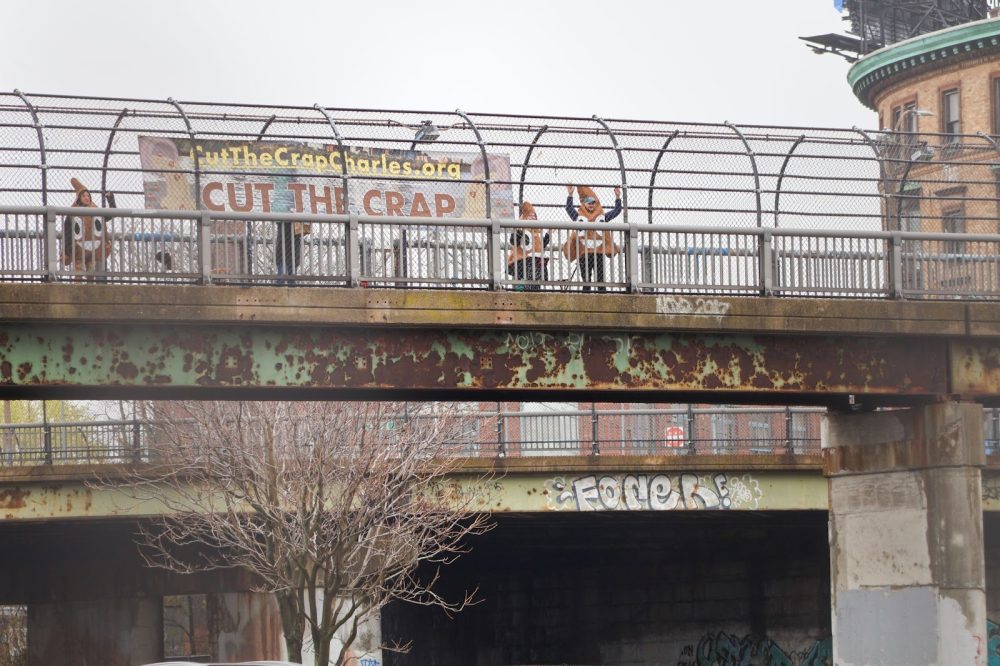
CRWA’s Cut The Crap campaign aims to create public awareness around CSOs and generate pressure on the Massachusetts Water Resources Authority (MWRA) and the Cities of Cambridge and Somerville to stop these sewer overflows from polluting the Charles.
The campaign website – CutTheCrapCharles.org – links to a digital petition demanding the full elimination of CSOs in the Charles, as well as pre-written messages supporters can send to MWRA, Cambridge and Somerville officials.
“When people hear we are still dumping sewage into the Charles, they are shocked and disgusted. Our problem is that not enough people are aware,” said CRWA Executive Director Emily Norton. “We hope that this action will help bring that awareness and inspire people to join our campaign to ‘cut the crap’ in the Charles!”
CSOs are a key source of contamination to the Charles and are becoming more frequent as our climate changes. In these outdated systems, stormwater and household/industrial wastewater are collected in the same pipes to be conveyed to a wastewater treatment plant, but during heavy rainstorms, the combined system cannot handle the excess polluted water and releases it into the river.
MWRA, Cambridge, and Somerville are required to carry out an extensive updated CSO planning effort to address the ongoing challenge of raw and partially treated sewage being dumped into the Charles River during heavy rain.
In August, the Massachusetts Department of Environmental Protection (MassDEP) issued a water quality standards Variance allowing MWRA, Cambridge and Somerville to continue discharging CSOs into the Charles River, Mystic River and Alewife Brook, delaying long overdue water quality improvements.
Sign up for the annual Charles River Herring Count
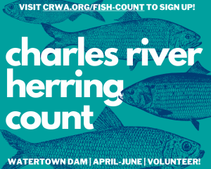 DATES: April 14 – June 30, 2025
LOCATION: Watertown Dam
DESCRIPTION: Each spring, thousands of migratory fish return to the Charles River to spawn from the ocean. But many are stopped short because of defunct dams.
Help the Charles River Watershed Association collect data on how many fish are able to use the ladder at Watertown Dam! By counting fish, you will play a critical role in understanding how dams affect American Shad, Blueback Herring, Alewives, Rainbow Smelt, White Perch, Striped Bass, and American Eel.
Canoeing/Kayaking
A good launch site for your small watercraft is at Elm Bank Reservation located at 900 Washington St., Wellesley. Take the paved road about 3/4 of the way around and look for the clearly marked canoe launch sign.
It’s bring your own boat here, and we recommend that you stick to non-motorized crafts. We’ve seen motorboats put in at Elm Bank, and as far as we know there’s no rule against doing so. But the river is generally quite low here, spiking in depth only in early spring and sometimes fall after heavy rains.
Cross country skiing, hiking along the Charles River
Elm Bank Reservation also offers a lovely, wide path that goes along the Charles River. Walkers, cross country skiers, and cyclists in the know love this peaceful, generally uncrowded stretch. Follow the paved road. When you pass the second of two darling cottages on the Elm Bank property, look for the small parking lot. The lot is available to Elm Bank visitors.


Also, try out this hike that includes the Waban Arches and Sudbury Aqueduct

Picnicking on the Charles River
On the Wellesley/Newton line on River St. in Wellesley there are a couple of picnic tables and benches available for dining with a view. Pick up sandwiches, soups, and salads from Express Gourmet across the street (11 River St.); or an amazing roast beef sandwich at nearby Mark’s Pizza & Subs of Wellesley (10B Washington St./Rte. 16 east.


