• Sign up for free email newsletter
  • Advertise
  • Donate to support our work
  • Events calendar
  • About Us
Boston Medical Center, Wellesley
 
Pinnacle, Douglas Elliman, Wellesley
 
Wellesley Hills Dental

The Swellesley Report

Since 2005: More than you really want to know about Wellesley, Mass.

  • Restaurants, sponsored by black & blue
  • Camps, sponsored by NEOC
  • Wellesley Square
  • Private Schools, sponsored by Prepped and Polished
  • Public Schools, sponsored by Sexton
  • Preschools, sponsored by Longfellow, Wellesley
  • School news
  • Kid stuff
  • Top 10 things to do
  • Business news
  • Worship
  • Letters to the editor
  • Guidelines for letters to the editor
  • Live gov’t meetings
  • Sports schedules & results
  • Deland, Gibson’s Athlete of the Week
  • Deaths
  • Housing
  • Medical providers—sponsored by FIXT Dental
  • Wellesley Wonderful Weekend
 

Top Stories

Special Town Meeting to address MassBay land plans
Wellesley celebrates Boston Marathon in style
Give & Take area re-opening

Advertisements

Needham bank ad
FIXT
Wellesley In Bloom
Down Under, Wellesley

Geology Walk: adventure through time at Hemlock Gorge with Wellesley Conservation Land Trust

April 23, 2026 by admin Leave a Comment

Wellesley’s own rock star, Chris Crowley will unearth the past during a geological expedition through Hemlock Gorge on Saturday, April 25, at 10am. Meet at the Echo Bridge trail head across from 27 Hamilton Place, Needham. There is a small parking lot at the trailhead.

Wellesley Conservation Land Trust
Chris Crowley, WCLT geology enthusiast

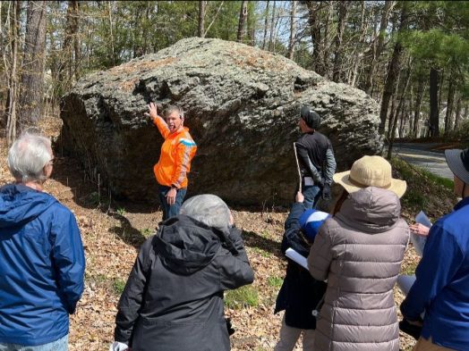
Sure, Hemlock Gorge as a scenic spot for a weekend stroll, but did you know that just below the trail’s surface lies the remnants of a  fascinating prehistoric past? Chris will peel back the layers of deep time, examining bedrock formations and the visible scars left by ancient glacial movements.

“If you have never been to the gorge, it is a gem,” Chris says. “There are terrific exposures of Roxbury Puddingstone and dramatic views of the Charles River and several dams.”

Registration is required. Participants are encouraged to wear sturdy walking shoes and bring water.

Filed Under: Education, Environment, Hikes


Advertisements

black & blue, Wellesley
Olive Tree Medical, Wellesley
taste of wellesley gif

Save the dates: Wellesley Trails Committee spring 2026 guided walks schedule has dropped

January 14, 2026 by admin

Wellesley Trails Committee

Filed Under: Environment, Hikes, Outdoors

Page Waterman, Wellesley
London Harness, Wellesley

Guided walk on Beard Trail in Wellesley & Needham: Saturday, May 3

May 1, 2025 by Bob Brown

The Wellesley Trails Committee invites you on a guided walk of the Beard Trail (2.3 miles) on Saturday, May 3, 10-11:15am.

Explore historic landmarks, unique geological features like puddingstone and an esker, lush wetlands via a scenic boardwalk, and winding forest trails that connect the past and present of Wellesley and Needham.

Meet at the map house located at Grove Street and Beard Way near the Needham town line. Please park on the left-hand side of Beard Way.

Walks are free, and no registration is required.  Participants are encouraged to wear sturdy footwear.

Walks and events take place unless it pours rain or there are high winds. 

wellesley trails beard trail

Filed Under: Hikes, Outdoors

Advertisements

Longfellow, Wellesley
Wellesley Wonderful Weekend
Wellesley Symphony Orchestra, 2026

Morses Pond Kids Trails Day rewards ‘hardy New Englanders’

September 22, 2024 by admin

The Wellesley Trails Committee this past weekend celebrated another successful Kids Trails Day, this year in the woods at Morses Pond.

Despite the rain, the event had a nice turnout that the Committee’s Joan Gaughan described as “a tribute to hardy New Englanders!” Kids, accompanied by adults, got into nature and searched for treasure boxes using written clues.

The Committee thanks Whole Foods for donating cider and donuts, and the Wellesley High School Key Club (and Wellesley Trails Committee members) for helping to make the activity possible.

Wellesley trails kids trails day

wellesley trails kids trails day


Next up on the Trails Committee’s event schedule:

Sudbury Path & Needham Aqueduct Trail walk

Saturday, Sept. 28 (10-11:15 a.m.) – 2.4 miles

Explore the trails that loop around Babson and Olin Colleges along the Sudbury Path and the town border between Wellesley and Needham. A highlight is a visit to the restored Babson World Globe, constructed in 1955 and still the world’s second largest revolving globe. Meet at Babson Skating Rink parking lot (southwest corner), 150 Great Plain Ave., Wellesley.


YES, sign me up for Swellesley’s free weekday email newsletter


Filed Under: Hikes, Kids, Morses Pond, Outdoors

Wellesley Kitchen and Home Tour
Hunnewell Fun Fair 2026

Charles River and general water news

This page was updated April 2026

Although New England’s most prominent river, the Charles River, flows right through Wellesley, it can be easy for residents to forget all about the 3.9-mile section that winds from the South Natick line to Wellesley Hills.  In all, the Charles glides 80 miles from its starting point in Hopkinton, Mass. to its eventual merger with Boston Harbor.

It does so on a stealth path through Wellesley. No main driving thoroughfares in town move along the river’s path. And the Charles can be so narrow in certain sections that it might be mistaken for a stream.

Getting to know the river is well worth it, however. You just have to know a few access points to open up this wonderful resource and connection to the natural world.


Wellesley resident named to Charles River Watershed Assoc. board

Frank Hunnewell, WellesleyThe CRWA welcomes Wellesley resident Frank Hunnewell to its Board of Directors, along with Katie Garvey and Charlie Hagedorn.

Hunnewell has also served on the board of the Massachusetts Horticultural Society, and the International Dendrological Research Institute, and on the board of advisors of the North Bennet Street School. He holds an AB from Harvard and an MBA from the Tuck School of Business at Dartmouth.


Wellesley on Level 2 drought status—water restrictions in place

At its Feb. 1, 2026 meeting, the Massachusetts Drought Management Task Force voted to place a Level 2 – Significant Drought status for our region. This limits outdoor watering to hand-held hoses or watering cans only. Sprinkler systems should not be used at this time. The State reviews drought conditions monthly, and we’ll notify customers through social media, our website, and the Town’s News and Announcements when restrictions change. Additional information and updates are also available on the State’s drought status webpage.

A drought is a period of drier-than-normal conditions that reduces water availability. While drought is often thought of and more noticeable in the summer months, drought can occur throughout the year. The state determines a drought by reviewing long-term data; in this case, conditions from August 2024 through December 2025 were analyzed.

While there have been minor improvements in some areas, drought conditions persist across much of Massachusetts. Local water supplies remain stable, but with reduced winter recharge, conserving water is essential.

Residents should limit outdoor water use, such as rinsing salt off vehicles or filling outdoor pools, to one day per week on Sundays. Residents are also encouraged to be mindful of indoor water use.


Update on CRWA’s “Cut the Crap” campaign

Nov. 14, 2025–Following a wave of public outrage over the Massachusetts Water Resources Authority’s (MWRA) recently-proposed plan to allow for sewage to continue to be dumped into the Charles River forever, the MWRA Board of Directors has tabled a scheduled vote on the proposal at its November 19 meeting.

“The public has responded loud and clear. No amount of sewage is acceptable to be dumped in our beloved Charles River,” said CRWA Executive Director Emily Norton. “We are glad to hear that MWRA is finally listening to public input and postponing a decision on this terrible proposal.”

During a meeting with its Board of Directors on Oct. 29, MWRA officials presented multiple options for addressing combined sewer overflows (CSOs) in the Charles, and recommended adopting the option that would increase sewage overflows by the largest amount.

CSOs are a key source of pathogen contamination to the Charles and are becoming more frequent as our climate changes. In these outdated sewer systems, stormwater and household/industrial wastewater are collected in the same pipes to be conveyed to a wastewater treatment plant, but during heavy rainstorms, the combined system cannot handle the excess polluted water and releases it into the river.

MWRA and the city of Cambridge are legally required to carry out an extensive CSO planning effort to address 9 of the 10 remaining CSO outfalls on the Charles, and must submit a preferred project option by the end of 2025. The national precedent for these plans, known as Long Term Control Plans, is to reduce the amount of sewage being discharged into a waterbody. MWRA proposing an increase was an unexpected outcome.

MWRA’s proposal recommended the state downgrade the legal classification of the Charles River. Massachusetts water quality standards currently classify the mainstem of the Charles as a “Class B” water body, which does not allow any CSOs. MWRA recommended a downgrade to a classification known as “Class B(CSO)” allowing it to dump sewage into the river forever.

MWRA is only allowed to dump sewage into the river today because of a variance it has received from MassDEP and U.S. EPA, which is intended to be a time-limited, interim measure while MWRA makes progress toward CSO elimination.

In April, CRWA launched its Cut The Crap campaign to create public awareness around CSOs and generate pressure on the MWRA and the City of Cambridge to stop sewage from polluting the Charles. Since then, nearly 8000 people have signed petitions or sent emails to the MWRA, urging them to “cut the crap” being dumped into the Charles River.

Charles River Watershed Assoc., cut the crap
Photo by CRWA

paddling on charles river kayak


Did FEMA just put your Wellesley home onto a flood map?

Nov. 2025–In July, FEMA released updated flood maps across the Charles, Nashua, and Merrimack watersheds, and many residents are finding that their homes are now included in flood zones for the first time. Unfortunately, though these maps are used to inform government-backed mortgage lenders who require flood insurance for the property, they are not entirely accurate.

“We don’t use FEMA maps that much, and we encourage communities to also not use them for planning purposes,” said Julie Wood, climate resilience director at the Charles River Watershed Association. “I know there’s a regulatory structure around the National Flood Insurance Program that these maps are central to, and that’s, of course, critically important. But our focus is on climate resilience planning and planning for the future that we know is coming, and these FEMA maps are not a good tool for that.”

Homes in flood zones require pricey flood insurance. Don’t wait for your mortgage lender to contact you about that (and they will). Here’s a map that will tell you if, in FEMA’s opinion, you’re in a prime spot for flooding. Given what Wood says, a new designation could be worth fighting.


Canoeing/Kayaking

A good launch site for your small watercraft is at Elm Bank Reservation located at 900 Washington St., Wellesley. Take the paved road about 3/4 of the way around and look for the clearly marked canoe launch sign.

It’s bring your own boat here, and we recommend that you stick to non-motorized crafts. We’ve seen motorboats put in at Elm Bank, and as far as we know there’s no rule against doing so. But the river is generally quite low here, spiking in depth only in early spring and sometimes fall after heavy rains.


Cross country skiing, hiking along the Charles River

Elm Bank Reservation also offers a lovely, wide path that goes along the Charles River. Walkers, cross country skiers, and cyclists in the know love this peaceful, generally uncrowded stretch. Follow the paved road. When you pass the  second of two darling cottages on the Elm Bank property, look for the small parking lot. The lot is available to Elm Bank visitors.

Nordic skiing, Wellesley
Nordic skiing, Wellesley. This is the second of two darling cottages on the Elm Bank property. When you see this one, there is a small parking lot nearby. The home is a private residence.


Nordic skiing, Wellesley
We love this loop for the Charles River views and the even, generally flat terrain. The trail has sections of Wellesley and Dover.

Also, try out this hike that includes the Waban Arches and Sudbury Aqueduct

Waban Arches, Wellesley
View from the Waban arches, heading toward Dover Road. To the right, Waban Brook makes its way through marshland on its way to the Charles River.

Picnicking on the Charles River

On the Wellesley/Newton line on River St. in Wellesley there are a couple of picnic tables and benches available for dining with a view. Pick up sandwiches, soups, and salads from Express Gourmet across the street (11 River St.); or an amazing roast beef sandwich at nearby Mark’s Pizza & Subs of Wellesley (10B Washington St./Rte. 16 east.)

Rotary Club, Taste of Wellesley

Centennial Park in Wellesley, early spring 2024

May 13, 2024 by Deborah Brown

We recently took a late afternoon hike at Centennial Park, 87-acres of Natural Resources Commission conservation land in the Wellesley Country Club/MassBay Community College end of town. The Oakland St. parking lot offers space for about a dozen cars at this spot popular with dogs and their human friends. NRC policy states pets “must be at all times under the immediate control of the owner or on a leash.” In Centennial Park, the dogs roam free, and “immediate control” seems up to interpretation.

AREA: Centennial Park, 135 Oakland St., Wellesley

RECENT HISTORY: Purchased from the Sisters of Charity of Mt. Saint Vincent by the Town in 1980 for Wellesley’s 1981 Centennial Celebration. Funding was provided by the Wellesley Conservation Council (now known as the Wellesley Conservation Land Trust) and the Friends of Centennial Park. The Wellesley Natural Resources Commission provides stewardship of the area.

HIGHLIGHT: View from the top of Maugus Hill, one of the highest points in Wellesley.

Here are a few pics:

Centennial Park, Wellesley


Centennial Park, Wellesley


Centennial Park, Wellesley


Centennial Park, Wellesley


Centennial Park, Wellesley
Elizabeth Seton Residence, top of hill. The residential care community is a ministry of the Sisters of Charity, owners of some 14 acres abutting Centennial Park. The Sisters would like to sell the property to a for-profit or non-profit that can manage the current assisted living and skilled nursing facilities on the campus through the lifetimes of nuns that retire there. But it will take a zoning amendment to make finding a buyer easier, according to the proponents. So far, discussion on the issue has not yet made it to Town Meeting.


Filed Under: Hikes, Outdoors

The Wellesley New Year’s Eve throw-down we weren’t invited to

January 3, 2024 by Deborah Brown

After a day of too much screen time and not enough movement, we decided to take a quick late-afternoon walk across the Waban Arches, which spans an offshoot of the Charles River. We already knew that the area is a popular spot for walkers, bird watchers, and graffiti artists. What we didn’t know is that it appears the Arches were the site of an explosive New Year’s Eve party.

First we came across a fire extinguisher lodged in a tree. Curious.

Waban Arches, Wellesley
How this fire extinguisher became lodged in the crook of a tree, far out of reach from the Waban Arches, should the need arise, is a mystery to us. Lucky toss?

Next we came across an empty bottle of Rolling Rock rolling around, as well as a bunch of beer cans.

Waban Arches, Wellesley
It’s not like we haven’t come across empties before on the 145-year old stone bridge located behind Nehoiden Golf Course. Such untidiness appears from time to time in the area where you can hear route 16 traffic, but still feel like you’re miles away.

Next, the true excitement. A couple empty boxes of Sailor’s Delight fireworks told a tale of “fiery red and gold palms, silver crackles and strobes, chrysanthemums, and pearls” that fill up the heavens, according to the online description. All that for only $35/box.

We didn’t need to look up a product description for the Rolling Rock or the fire extinguisher, having had previous experience with both. (Not at the same time.)

Waban Arches


Waban Arches, Charles River, Wellesley
Presumably the fireworks were launched off the Arches so as to see the display reflected in the water. 2020 picture from our kayak paddle in the area.

We didn’t dare explore further to discover what might be found under the Arches. Sometimes common sense must prevail when walking in a lonely area as dusk approaches. I would have lit a Sailor’s Delight to guide my way (what could have gone wrong there?), but somebody didn’t leave any delight for others.

Waban arches, Sudbury aqueduc
Waban Arches, 2020 picture.

Happy New Year, Wellesley.

If you’re interested in hiking the Waban Arches and Sudbury Aqueduct area, here’s our post about the spot. The Arches are on the National Register of Historic Places.


  • Subscribe to Swellesley’s daily email
  • If you like what we do and want to help, please consider making a completely non-deductible contribution

Filed Under: Hikes, Holidays

Wellesley hike: The trails were fragrant along Longfellow Pond

October 25, 2023 by Deborah Brown

If you’re looking for a quick and pretty walk in Wellesley with water views, changing fall foliage, and the scent of pine trees—and perhaps some other olfactory exposures—try out the trails in the Longfellow Pond area, a small section of the 221-acre Wellesley Town Forest. You can’t miss the Oakland Street parking lot, or the trailheads, which you can access on either side of the lot.

Longfellow Pond, Wellesley
Longfellow Pond, October, 2023

I waked toward the trailhead to the right as I faced the pond, and set out for a pleasant experience. As I made my way along the wide path, I took a deep breath of autumn. Inhale—ahh, the crisp, cool temperatures awakened me from a mid-afternoon slump. Exhale—let’s power walk, baby. Another inhale—the strong smell of cigarette smoke. Wait, what? No way I’m going to breathe secondhand smoke during my commune with nature. When two paths diverged in a wood, I grabbed my chance and took the one less smoked on, banking right to hike up the steep esker, marked with the red trail arrows.

There’s irony here. As Josh Dorin has pointed out in his Wellesley History blog, “Longfellow Pond is not natural. Rather, it’s entirely man-made and, furthermore, very little of the surrounding environment has been untouched by humans. Look closely and this should be obvious, from the dam and concrete piers at the north end of the pond to…the sewer and gas lines that run underneath the pond.”

Here are some pictures of my hike, along with some musings, and a little history about the area.

The foliage was just starting to turn during my mid-October hike in this area that looks perfectly preserved, but that’s actually been nipped and tucked more often than a Hollywood celebrity. In 1815, Rosemary Brook was permitted to be dammed at the request of business owners. The result was Longfellow Pond. Industrial concerns came and went over the years, among them a nail factory and a paper mill. But it was the ice house that lasted the longest, harvesting frozen blocks from the pond from the late 1800s through until the 1920s. Remnants can still be seen along the shores.

The days are now rare when the shallow Longfellow Pond, which reaches a depth of only about 5 feet, freezes solid enough to harvest blocks (a [Read more…]

Filed Under: Hikes, History

Next Page »

Tip us off…

Please send tips, photos, ideas to theswellesleyreport@gmail.com

Please support your local online news source with a tax-deductible donation by scanning the QR code
or by clicking on it.

QR Code

Advertisements

Wellesley Square Merchants
Wellesley, Jesamondo
Fay School, Southborough
Sexton test prep, Wellesley
Feldman Law
Wellesley Theatre Project
Prepped and Polished Boston Tutoring and Test Prep
Perdocere, Wellesley
Wonder Run, Wellesley
Center for Life Transition
Natural Resources Commission, Wetlands, Wellesley
Admit Fit, Wellesley
Human Powered Health, Wellesley
charles river chamber
entering-swellesley-1
  • Bluesky
  • Facebook
  • Instagram
  • Twitter

Subscribe to our free weekday email newsletter

* indicates required

Follow Swellesley on Google News Showcase

The Swellesley Report has been selected to be highlighted on Google News Showcase. Please follow us there.

Most Read Posts

  • Great spring running events in Wellesley (and beyond)
  • Friday is letters-to-the-editor day—read what Wellesley Middle School students have to say
  • What drought? Wellesley rescinds outdoor watering restrictions
  • Boston Marathon 2026: Wellesley guide
  • Wellesley celebrates the Boston Marathon in style

Click on Entering Natick sign to read our Natick Report

Entering Natick road sign

Recent Comments

  • Robin Banks on Survey says? Share your thoughts about the Wellesley DPW
  • Mike Hines on Wellesley Select Board approves Special Town Meeting article language on MassBay land plans
  • Andrew Mikula on Wellesley kicks off Affordable Housing Trust 5-year action plan process
  • Frank Pinto on Wellesley kicks off Affordable Housing Trust 5-year action plan process
  • Joan on Wellesley Select Board approves Special Town Meeting article language on MassBay land plans

Calendar

Upcoming Wellesley events

Upcoming Events

Apr 23
9:00 am - 3:00 pm

Wellesley Police blood drive at station

Apr 23
1:00 pm - 2:00 pm

Discover Our Local Butterflies at Wellesley Free Library (ages 5+)

Apr 23
7:00 pm - 8:30 pm

Comedy Night in Wellesley at Lockheart

Apr 24
8:45 am - 9:45 am

Walk with a Doc, sponsored by Olive Tree Medical

Apr 25
10:00 am - 11:00 am

Wellesley Conservation Land Trust Geology Walk

View Calendar

Links we like

  • Danny's Place
  • Great Runs
  • Tech-Tamer
  • Universal Hub
  • Wellesley Sports Discussion Facebook Group

© 2026 The Swellesley Report
Site by Tech-Tamer · Login